|
|

|
|

|
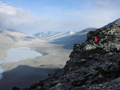
A
view of Wright Valley, an Antarctic Dry Valley. The laser
mapping team visited the valley in person before mapping
it from the air.
Click to Enlarge
.
|
|
|
|
|
|
|
Shooting
the Ground
|
|
|
Mapping
the Dry Valleys with Laser Light
by Paul Doherty
January
1, 2002
NASA
scientist Bill Krabill has been watching the Greenland icecap
with a laser altimeter for a decade. By carefully measuring
the height of the ice surface to within the width of a human
hand (10 cm) he found that over 50 cubic kilometers of ice
is vanishing each year. That is enough ice to cover the city
of San Francisco to a depth 5 times the height of the towers
on the Golden Gate Bridge (a kilometer deep), enough melted
ice to raise sea level by the width of two human hairs (0.13
mm). Why is the ice melting? We don't know, but before the
measurements by Bill and his ATM, Airborne Topographic Mapping,
team we didn't even know that it was melting.
The
Antarctic Ice Cap is immensely larger than Greenland's. Is
it shrinking, growing, or staying the same? the ATM team is
down here to find out. The funny thing is that to find out
what's happening to the ice they are measuring the ice free
regions known as the Dry Valleys. Antarctica is such a vast
continent they could never map it by aircraft, so NASA is
sending up a satellite, ICEsat with a laser altimeter to map
the continent. ICEsat will calibrate itself by measuring the
unchanging topography of the Dry Valleys and then move on
to measure changes in the ice.
|
|
|
|
|
|
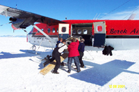
Loading
the instruments of modern physics into an aircraft using
an ancient tool, the inclined plane.
Click to enlarge
.
|
|
|
|
|
|
The
ATM team loaded their laser altimeter onto a Twin Otter aircraft.
The laser altimeter, or LIDAR, instrument is like the ones
that State police use to catch speeders on the highway, this
one shoots foot-long green laser pulses at the ground and
times how long it takes the scattered pulse to return to the
aircraft. The round trip travel time gives the distance from
the aircraft to the ground. (In a similar way if you clap
your hands in the mountains you can time the return of the
sound echo and find out how far you are from a cliff, 500
feet for every round-trip second) To find out where the ground
is, Bill needs to find out where the aircraft is to within
a few centimeters! This seemingly impossible job is accomplished
with the aid of the Global Positioning Satellites, GPS. A
reciever on the aircraft uses the travel time of radio signals
from several satellites to figure out its exact location on
and above the earth. And finally, the team needs to know which
way the beam is pointed, down, forward or to the side, for
this they use an inertial navigation unit to sense the orientation
of the aircraft. (You have a biological inertial navigation
unit in your inner ear which helps you sense which way is
down and whether you have changed rotation rate. NASA uses
inertial navigation units in spacecraft.) These electronic
senses are fed into a computer which calculates the height
of the ground. Each second the system makes 5,000 precise
measurements, then the computer builds the best topographic
map ever made of the land beneath the airplane.
|
|
|
|
|
|
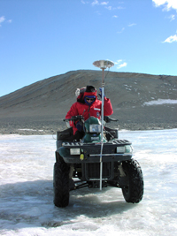
An all Terrain vehicle sports a GPS receiver antenna as
it maps Lake Thomas.
Click
to Enlarge
.
|
|
|
|
|
|
One
amazing thing is that we have already mapped Mars by laser
altimeter and are only now getting around to our own planet.
The
ATM team is setting a fine example of how to do science, they
process their data as they take it. This lets them catch any
problems and fix them without wasting time. This means that
the team has to ride in the planes with the instruments, and
the plane ride is a wild one. The pilot has to constantly
push the rudder pedals all the way to the floor to keep the
plane precisely on course to make the map. The team members
report that the views of the Dry Valleys are worth the wild
ride.
The
ATM team is in an interesting middle position. The ICEsat
will use their measurements to calibrate its laser altimeter,
while the team itself must acquire ground truth measurements
to calibrate their system. To do this they use a flat-surfaced,
frozen lake in the Dry Valleys, Lake Thomas. They surveyed
Lake Thomas using a GPS system mounted on an All Terrain Vehicle,
ATV.
So
from bumping across the ice in an ATV, to being thrown around
in an aircraft shooting the ground with a laser, to sitting
in an office and analyzing data from a satellite, scientists
are trying to find out exactly what is happening to the Antarctic
Ice sheet. Trying to add this one important piece to the giant
jigsaw puzzle that is the earth's climate.
|